Categories
Central Sierra Climate Change Tahoe Snowstorms Tahoe Weather Weather History

#292: Winter 2023: Facts, not Hyperbole

Now that the snow has settled from the monster winter of 2023, it’s time that we dismiss the sensational headlines and understand that it was not the record season for snow and water in the Tahoe Sierra that the media would have you believe. References to “record snow/precipitation” continue even though data indicate otherwise.

That’s not to say it wasn’t an epic season in California. Officially, 2023 ranks 5th for snowfall at Central Sierra Snow Laboratory near Donner Pass (since 1880), and 5th for snow and 3rd for cold at Tahoe City where weather bureau measurements began in 1909, the longest dataset in the Tahoe Basin.  

NOAA does not use snowfall data from ski areas in its official tallies, but in the Sierra high country incessant atmospheric rivers coupled with consistent below normal temperatures in 2023 translated into seemingly endless powder dumps.

A few California ski resorts set new maximum snowfall records for their locations, including Palisades Tahoe (Squaw Valley) with 723 inches at 8,000 feet elevation. Mammoth Mountain in the southern Sierra blew past its old record with 885 inches (74 feet). Mammoth is still open with top to bottom skiing so get out there if you still need more runs in your quiver.

In the Great Basin, at least 8 Utah resorts set new maximum snowfall totals. Alta Ski Area set a record with 903 inches (75 feet) by the time it closed at the end of April 2023. The region is famous for its light fluffy snow, but for those who got a taste of the bottomless “cold smoke powder” this winter will be bragging about for years to come. Utah hydrologists tallied 30 inches of snow water equivalent (SWE) in the snowpack statewide, also a record.   

In April 2023 I created a Power Point presentation for a client that briefly analyzes last winter’s impact in the Tahoe Sierra and its historical ranking for snow and precipitation. (Precipitation is the combination of rain and water equivalent of snow.) I extracted about 10 slides to illustrate this Tahoe Nugget.


The Northern Sierra is the most important region in California for water storage captured from runoff draining the normally wet watershed north of Highway 50 to Mount Shasta. The Northern Sierra 8-Station Index was established in 1922 to provide hydrologists with vital, real-time data regarding precipitation values throughout this vast region. Note that the precipitation value for 2023 is well shy of the top water years.

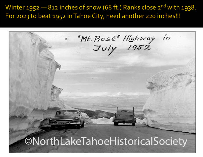
Tahoe City’s 316 inches (26.3 ft.) of snowfall in 2023 was good enough for 5th place, but needs another 220 inches ((18.3 ft.) to overtake the 1st place winter of 1952! Check out the July 1952 snowpack below.

I’ve used this slide for years. General Mariano Vallejo was an important Californio and ally of the United States in the Mexican American War (1846-48). Despite the fact that the Americans arrested and confined him to prison for no good reason. Vallejo is not talking about climate change in the modern sense, he’s commending the Americans for their industry and can-do spirit.

Follow Mark McLaughlin on Facebook

Read my bi-weekly column in Tahoe Weekly magazine.

Categories
Tahoe Weather

#288: WINTER UPDATE: TAHOE LOSES TO CORONAVIRUS

Lake Tahoe succumbed to Coronavirus mitigation in a big way last weekend. Just before lucrative Spring Break week and as the juiciest storm of this sketchy winter season was rolling in, Vail Resorts decided to close their three popular ski areas in the region — Northstar, Heavenly Valley and Kirkwood — due to the virus and its potential health impacts on their employees and guests: Other resorts, big and small, corporate or privately-owned, briefly resisted the sudden and unprecedented move, but then quickly fell in domino fashion.

Cross-country and back-country alpine skiing, snowshoeing and snowmobiling are still robust outdoor activities to be enjoyed, especially in all the fresh snow falling this week, but they represent a minuscule fraction of the region’s important winter economy. As a final nail in the coffin, brew pubs, bars, wine tasting rooms, casinos and restaurant dining rooms are closing too. Wow! So that’s where we stand.

Let’s roll back the tape and review how this winter played out up to this point. Here’s a quick photo essay:

A Sept. 29 snowfall got the juices flowing for an early winter, but the next two months were warm and bone dry. In early November, Squaw Valley fired up its snow-guns although warm temperatures limited production. This is the base-area beginner area for little tykes. The weather-protected moving carpet conveyance whisks kids along as young as 3 up for their first lessons.

A parade of cold winter storms beginning Thanksgiving weekend did wonders for skiing and riding conditions at Tahoe resorts. Squaw Valley looking good for early season.

High pressure in January 2020 kept storms away, but let low-level stratus clouds form due to temperature inversions. In a mixing atmosphere it’s warmer at the surface and the air temperature cools with altitude. An inversion reverses that temperature profile and the colder air near the surface triggers the formation of ground or low-level clouds. This photo from Diamond Peak ski resort shows an inversion-cloud formation over western Nevada looking south.

Low-level inversion clouds in the Tahoe Basin on January 25, 2012. I took this image from the Mt. Rose Highway under a full moon. Looking west with Squaw Valley in distance on right.

After a record-setting February with virtually no rain or snow, on March 14 the National Weather Service warned that the biggest storm of the winter was heading to the Sierra. This was not a jet stream-driven cold front barreling through, it was a slow-moving system that was going to drift around for awhile giving it time to put down some decent snow and precipitation. In fact, it’s still overhead but weakening today. (March 19, 2020).

In three days, the Sierra snowpack improved markedly, but the regional watershed is still suffering a severe water deficit. There are more cold and wet storm systems expected in the first part of next week, but the pace will have to pick up to erase the hydrologic deficit and make this a proverbial “Miracle March.”

Associated Press photo from Heavenly Valley after the storm’s first snowfall had really improved skiing conditions in the Tahoe Sierra — with much more to come. Unfortunately, due to the Coronavirus pandemic, within days all resorts had closed for the season.

This graphic is courtesy of Jan Null, owner of Golden Gate Weather Services. A quick look confirms that parts of southern California got its fair share of precipitation this winter, but the most vital watershed and reservoir systems are all in the north state. The 55% bubble in the northern Sierra Nevada represents the 8 Station Sierra Index, the critical aggregate of 8 important precipitation gauges on the Sierra west slope. Conditions are even more desiccated in the southern Sierra.

View past the historic Thunderbird Lodge on the point looking towards Mt. Tallac and the beautiful, high-elevation Desolation Wilderness area, circa January 2020. There may be a nasty bug skulking around, but nothing can take away from the breathtaking beauty of a Lake Tahoe winter. Even a sketchy one.

BE SMART & STAY HEALTHY!!! 

LIMITED TIME OFFER!!! Get a FREE COPY of Sierra Stories: True Tales of Tahoe, Vol. 1 with the purchase of SNOWBOUND! (A $14.95 value!!!) http://thestormking.com/Buy_Books/buy_books.html

ARCHIVE for Mark’s Tahoe Weekly magazine articles. https://thetahoeweekly.com/author/mark/

VIEW RECENT NUGGETS.

http://tahoenuggets.publishpath.com/

SIGN UP FOR TAHOE NUGGETS

mark@thestormking.com

BOOKS, WEATHER HISTORY & MUCH MORE!!!

www.thestormking.com

UNSUBSCRIBE

Email: mark@thestormking.com Subject: UNSUBSCRIBE TAHOE NUGGETS

Categories
Tahoe Weather

TAHOE NUGGET #276: TAHOE WINTER UPDATE

It’s no secret that it’s been a very stormy winter in the Tahoe Sierra. In fact, snowfall totals during the month of January set new records at Donner Pass, Tahoe City and most ski resorts. But the real story in winter 2017 is hydrologic. Nearly a dozen Pacific-bred Atmospheric Rivers have produced phenomenal amounts of precipitation in a short period of time.

If you look to the far right-hand side of the graph, you can see how much more snow fell this January at the Central Sierra Snow Laboratory near Donner Pass than the preceding 45 years’ worth of Januaries. The 237 inches of snow blew away the old Jan. record set at the Lab in 1982. It also easily beat the all-time monthly snowfall record there, measured during the “Miracle March” of 1992.

Carnelian Bay is definitely not the snowiest location in the Tahoe Basin, but it has has really piled up this winter in the "banana belt." Peak ridge wind gusts this February reached 199 mph! The strongest storms that crash into the Tahoe Sierra reach Category 3 Hurricane strength. 

January's heavy snowfall set the stage for long power outages, extensive road closures and frequent avalanches.

Resort totals are impressive: Alpine Meadows & Squaw Valley report more than 47 feet so far. Mt. Rose, where its high elevation converts mild AR rain to snow, leads regional ski areas with nearly 54 feet. Snowpack base amounts at Tahoe Basin resorts range from 8 to 22 feet deep.

In 2015, many streams, rivers and reservoirs in Northern California were near record lows; today officials are releasing torrents of water to make room for the looming spring melt of the massive mountain snowpack. The current “snow water equivalent” (SWE) in the expansive Northern Sierra pack is approaching 6.5 feet. At this time the federal water master for Lake Tahoe is releasing 500 cubic feet-per-second out of Big Blue to make room for the coming melt.

In early December 2016, the outlet of Lake Tahoe was just dirt with a lake level below the natural rim. Since October 1, Tahoe has risen nearly 4 feet and is now at 6,226.81 feet above mean sea level. Approximately 139 billion gallons of water have been added to Big Blue so far this season. That’s enough to supply the average annual water consumption for 435,500 four-member households. 

These piers were high and dry last year. Given that the snow water equivalent (SWE) of the Tahoe Basin snowpack is more than 230% of normal, it’s a foregone conclusion that the lake will rise to its maximum legal limit by this summer. It will be the first time since 2006.

Still on pace to be the wettest winter in the Northern Sierra since 1922. Prodigious precipitation during the past 90 days has virtually extinguished a desiccating 5-year drought throughout most of California and Nevada. In January, much of that moisture fell as snow thereby ensuring a strong spring runoff.

Lake Tahoe’s water level is rising rapidly. Tahoe City has recorded more than 56 inches of precipitation in the form of rain or SWE. That is the greatest amount for October through February on record, beating the previous benchmark set in 1969 by more than 10 inches. Even without additional moisture through March, this year already beats the 6-month record by 2 inches, set in 1982.  

Snowfall on Donner Pass this winter has been epic, but still not enough to make the Top 10 list in SNOWBOUND! 

CLICK HERE<< TO PURCHASE SNOWBOUND! AN ILLUSTRATED HISTORY OF THE TOP 10 BIGGEST WINTERS IN THE TAHOE SIERRA.

CLICK HERE<< TO SIGN UP FOR YOUR FREE TAHOE NUGGETS.

CLICK HERE << TO VIEW MOST RECENT NUGGETS.

CLICK HERE<< TO READ MARK'S TAHOE STORIES & ARTICLES.

VISIT THESTORMKING.COM FOR ARCHIVED NUGGETS & MUCH MORE!

 ***MOST PHOTOS AVAILABLE AS PRINTS FOR FRAMING.

Categories
Tahoe Weather

#272 FLOOD OVER: BLIZZARD WARNING IN EFFECT!

A Blizzard Warning is in effect for the Tahoe Sierra until tomorrow morning. Heavy snow driven by high wind has created whiteout conditions on area highways and forced I-80 in the heavy snowbelt to remain closed all day. Placer County Emergency Services is doing robo-calls to alert residents that travel on regional roadways is highly discouraged except for critical needs only. And for the third day in a row, most Tahoe ski resorts remained shut down due to flood danger followed by overwhelming snowfall and avalanche concerns.

Flood-related damage is being reported all over Northern California and Western Nevada due to heavy rain in preceding days, but despite concerns main stem river flows on the Truckee, Carson and Walker rivers did not reach the destructive level they achieved during similar conditions in 2005-06. Certainly not even close to the catastrophic New Year's Flood of 1997. And now, snow levels have dropped and reduced flow issues in Nevada. I will revisit the mid-winter flood history of our regional rivers in a future Nugget. 

Snow began to pile up in Carnelian Bay last night with heavy snow all day today.

Picked up close to 5 feet of snow in the past 30 hours here at the Lake. Snow management gets to be a full time job during storms like this!

Today's water vapor satellite image shows the deep plume of moisture being tapped by this Atmospheric River. What it doesn't show is the cold air that infiltrated our onshore flow and lowered snow levels, which began to curb flood potential.

Squaw Valley looked pretty good when I there in mid-December, but the popular KT-22 chairlift was not running due to a lack of cover. Since my visit the upper mountain has picked up an additional 12.5 feet of snow not counting today's blizzard. Once our weather settles down, skiing and snowboarding are going to be epic! Just in time for the Martin Luther King, Jr. holiday coming this weekend.

CLICK HERE<< TO SIGN UP FOR YOUR FREE TAHOE NUGGETS.

CLICK HERE<< TO VIEW MOST RECENT NUGGETS.

VISIT THESTORMKING.COM FOR ARCHIVED NUGGETS & MUCH MORE!

***ALL TAHOE NUGGET PHOTOS ARE AVAILABLE AS PRINTS FOR FRAMING.

Categories
Tahoe Weather

#271 FLOOD WARNING IN TAHOE SIERRA

Hydrologic conditions are ripe today and tomorrow for a major flood in the Tahoe Sierra after previous cold storms dumped close to 8 feet of snow on area resorts this week. Now, temperatures have warmed considerably since early this week as a potent Atmospheric River of moisture surges into the West Coast. During a 36 hour period that began last night we're expecting between 6 to 12 inches of water, mostly rain below 8,000 feet in elevation. NWS forecasters are warning that rivers and streams are at high risk of flooding, similar to the 2005-06 event which caused $300 million in damage to California.

Tahoe has received record amounts of precipitation so far this winter. This graphic indicates how much snow fell in little more than 4 days earlier this week. Squaw Valley USA recorded 94 inches in the past 7 days and we are expecting heavy snowfall on and off all this upcoming week. This Nugget is being rushed out the door as the power has already flickered several times this morning. 

Here in the "Banana Belt" in Carnelian Bay we picked up only 3 feet of snow during the storms this week. First "major" snow event at lake level this winter. Snow levels have trended higher this year due to the prominence of subtropical Atmospheric Rivers.

Placer County's snow management is second to none. Within a day or so after the snow stopped falling this rotary snowplow was grooming the residential streets of Carnelian Bay. 

This is today's infrared satellite image from 8 kilometers above the planet's surface. It shows the classic synoptic pattern of an Atmospheric River with moisture surging into California. A stalled, deep low pressure system off the coast of Canada is spinning in a counter-clockwise rotation bringing copious moisture up from the subtropics. If the cold Alaskan low was closer snow levels would be lower and the Tahoe Sierra would be experiencing many feet of snow as opposed to flood potential.

Statistically, the Truckee River experiences a damaging flood every 9 years or so. It's been 11 years since the 2005-06 event. This storm is right on time! This flood warning is still in the process of verifying as heavy rain and wind continues to slam the Sierra today and tonight. Depending on the actual magnitude of this "wet mantle" flood, a follow-up Nugget will draw a comparison between this event and several past major floods. Many of which also occurred duing ENSO-neutral or weak La Niña episodes. Stay tuned.

CLICK HERE<< TO SIGN UP FOR YOUR FREE TAHOE NUGGETS.

CLICK HERE<< TO VIEW MOST RECENT NUGGETS.

VISIT THESTORMKING.COM FOR ARCHIVED NUGGETS & MUCH MORE!

***ALL TAHOE NUGGET PHOTOS ARE AVAILABLE AS PRINTS FOR FRAMING.

Categories
Tahoe Weather

TAHOE NUGGET #270: WETTEST START TO WINTER ON RECORD!

Heavy rain and high-elevation snow this October and December have gone a long way to mitigating the extreme drought conditions plaguing the Tahoe Sierra. A series of strong Atmospheric Rivers from the Pacific Ocean have pumped up water levels in Lake Tahoe and for the first time in months a strong current of water is now flowing into the Truckee River. The official start to winter is still days away!

The 8-Station Index represents precipitation values for the Northern Sierra. The 28.4 inches received since October 1 is more than 50% of what the region averages in a year. In many locations the month of October was the wettest of record. One storm alone added 11 billion gallons to Lake Tahoe, raising it 3 inches. Despite the boost, Big Blue still remained more than 2 inches below its natural rim. The current pace of precipitation is better than the beginning of Winter 2011, which ultimately ranked in the Top 10 as No. 8 wettest since 1871.

One Atmospheric River in October dumped more than a foot of water on Alpine Meadows ski resort. The most recent AR this past week delivered nearly 6 inches of rain in 24 hours. Snow levels in mild AR events are often quite high, sometimes between 8,000 to 9,000 feet in elevation. With a summit near 11,000 feet, Mammoth Mountain Resort near Yosemite was slammed with nearly 5 feet of snow on Dec. 16. The State record is 68 inches in 24 hours. Compare that with Tahoe's relatively low numbers for this same event. Tahoe resorts currently boast upper mountain bases ranging from 3 to 4 feet. Mammoth Mountain's snowpack is already 11 feet deep up top.  

Dec. 7, 2016 — Lake Tahoe was below its rim and the outlet to the Truckee River was dry.

Dec. 17, 2016 — Enough rain fell to raise Big Blue over its rim by several inches, creating a robust flow of water into the Truckee River for the first time since last summer. 

Despite relatively high snow levels in recent storms, the ski slopes are looking good for this time of year. Just in time for the crush of crowds that will be showing up for the holidays.

Early December at Donner Peak as viewed from Old Highway 40.

Chris Burt is the author of Extreme Weather: A Guide and Record Book.

***Don't forget to follow my Sierra Stories column!!! 

CLICK HERE >> TO SIGN UP FOR YOUR FREE TAHOE NUGGETS!

VISIT THESTORMKING.COM FOR ALL THE NUGGETS AND MUCH MORE!

***ALL TAHOE NUGGET PHOTOS ARE AVAILABLE AS PRINTS FOR FRAMING.

Categories
Tahoe Weather

NEW BOOK "SNOWBOUND!"

SNOWBOUND! is not a meteorology book, but it is about weather.

This well-illustrated, 8.5″ X 11″ publication focuses on the Top 10 biggest winters in the Tahoe Sierra based on snowfall measured at Donner Pass since 1879.

Its 160 glossy pages are loaded with amazing weather facts and incredible stories of men and women struggling to cope against some of the most powerful storms on Earth.

More than 250 large contemporary photographs bring the drama to life.

This coffee table quality book is dedicated to all who love mountains in winter, and to California’s Caltrans and Donner Pass railroad crews — “Sierra Snowfighters” — who battle the Storm King every winter to keep our highways safe and our railways clear.

Purchase your autographed copy of SNOWBOUND! at local Truckee-Tahoe stores or securely online at the STORM KING website for only $34.95 including sales tax and shipping.

This book will captivate anyone who loves trains or the challenge of an epic Tahoe winter.

THE PERFECT FATHER’S DAY GIFT!


Categories
Avalanche! Tahoe Weather Weather History

#230 WINTER OF 1982

TAHOE NUGGET #230: WINTER OF 1982

It’s been 30 years since one of the deadliest avalanches in Sierra Nevada history broke loose at Alpine Meadows Ski Resort and killed seven people. For those of us who remember this tragic event on March 31, 1982, and the days of grief and hope that followed, it represents a benchmark in time. The 15.5 feet of snow that fell at the Central Sierra Snow Lab between March 27 and April 8, 1982, still ranks as the greatest single snowstorm total on record for Donner Summit.

Miraculously, Alpine Meadows employee Anna Conrad survived for 5 days in the avalanche debris before she was rescued. She lost parts of both legs to frostbite, but after the surgery she was fitted with prosthesis. Today, she and her husband reside at Mammoth Lakes, California, where Anna is employed as a snow hostess for the resort.

Anna (Conrad) Allen survived the 1982 avalanche at Alpine Meadows. She suffered frostbite injuries, but later moved to Mammoth Mountain where she lives with her husband.

For anyone who skis or snowboards today, whether backcountry or controlled resort, the 1982 avalanche still serves as a reminder that the rugged mountains and dynamic weather we love so much are powerful forces of nature that deserve respect and understanding.

Read a short version of the story here: Tahoe Nugget #60

The winter of ’82 was also noteworthy for an extreme precipitation event that occurred in January. From Jan. 3-5, torrential rains caused extensive damage and destruction in the lowlands of the central and northern parts of California and heavy snows fell in the highest mountains. The San Francisco-Bay Area experienced the heaviest rainfall in 25 years. On January 4, San Francisco was doused with 6.16 inches of rain which is still the greatest one day storm total there in 159 years of rainfall records. 

The Santa Cruz Mountains were inundated with 10 to 20 inches of rain in 30 hours. The National Weather Service reported more than 8 inches of rain in one day there, the greatest 24-hour rainfall since 1890 when record keeping began. Considered one of the worst storms of the century, several thousand people were flooded out of their homes and at least 33 killed. Trains derailed, schools and highways were closed, and damage was estimated at $300 million.

Avalanche path near Mt. Tallac at South Lake Tahoe.

When the saturated air mass encountered the Sierra Nevada, precipitation intensified due to topography and orographic enhancement. The Echo Summit weather station at Sierra Ski Ranch, elevation 7,450 ft., is approximately ten air miles southwest of South Lake Tahoe, on the upper western slopes of the Sierra Nevada. The station is located near the Sierra Nevada crestline in an area where the well-defined ridge has a northwest-southeast orientation. Situated on a north-facing slope, the site is a choice area for maximum snowfall production.

24-hour snowfall of 67 inches set a new California record in January 1982.

Weather maps of this event indicated a strong zonal flow with very moist air moving west to east across the Eastern Pacific. This juicy fetch of moisture from the southwest collided with colder air flowing down the eastern side of a high-pressure system centered over the Gulf of Alaska. At Echo Summit, 67 inches of snow (5.6 feet) fell in just 24 hours, which ranks it as the second greatest single day snowfall total in the United States. The North American and world records are held by Silver Lake, Colorado, which received 76 inches (6.3 ft.) in 24 hours on April 14-15, 1921.

Overnight snowfall in the “banana belt” neighborhood of Gateway west of downtown Truckee.

The Jan. 4-5 storm that dumped up to five feet of snow in the mountains was only one in a series of powerful snowstorms that had been hammering the Sierra Nevada over the New Year’s Holidays. The Central Sierra snowpack exceeded 11 feet in depth, and nearly a dozen avalanches had roared through the Donner Summit. Thousands of motorists were stranded when highway crews shut down Interstate 80. The two-day total of 80 inches (Jan. 3-5) recorded at Echo Summit during this 1982 event ranks third in California.

The Tahoe snowpack was huge by mid-April 1982. My brother Tom came out for a visit in March and ended up staying an extra week because we couldn’t get to Reno for a departure flight.

Interestingly, just three months after the Jan. 1982 event, on March 30-31, a 65-inch snowfall was recorded in 24 hours at Twin Lakes, California, only eight miles south of Echo Summit. The two-day total from March 30 to April 1, 1982, at Twin Lakes was 90 inches, the second greatest 48-hour snowfall total in U.S. history.

On January 11-12, 1997, Montague, New York, located just east of Lake Ontario, reported a new record of 77 inches in 24 hours. The measurement was disallowed, however, after the National Climate Extremes Committee determined that the total was achieved by adding six measurements together, two more than the maximum allowed during any 24-hour period.


 Town of Truckee during the big storm that caused the Alpine Meadows avalanche.

 Sign up for Tahoe Nuggets!