Categories
Central Sierra Climate Change Tahoe Snowstorms Tahoe Weather Weather History

#292: Winter 2023: Facts, not Hyperbole

Now that the snow has settled from the monster winter of 2023, it’s time that we dismiss the sensational headlines and understand that it was not the record season for snow and water in the Tahoe Sierra that the media would have you believe. References to “record snow/precipitation” continue even though data indicate otherwise.

That’s not to say it wasn’t an epic season in California. Officially, 2023 ranks 5th for snowfall at Central Sierra Snow Laboratory near Donner Pass (since 1880), and 5th for snow and 3rd for cold at Tahoe City where weather bureau measurements began in 1909, the longest dataset in the Tahoe Basin.  

NOAA does not use snowfall data from ski areas in its official tallies, but in the Sierra high country incessant atmospheric rivers coupled with consistent below normal temperatures in 2023 translated into seemingly endless powder dumps.

A few California ski resorts set new maximum snowfall records for their locations, including Palisades Tahoe (Squaw Valley) with 723 inches at 8,000 feet elevation. Mammoth Mountain in the southern Sierra blew past its old record with 885 inches (74 feet). Mammoth is still open with top to bottom skiing so get out there if you still need more runs in your quiver.

In the Great Basin, at least 8 Utah resorts set new maximum snowfall totals. Alta Ski Area set a record with 903 inches (75 feet) by the time it closed at the end of April 2023. The region is famous for its light fluffy snow, but for those who got a taste of the bottomless “cold smoke powder” this winter will be bragging about for years to come. Utah hydrologists tallied 30 inches of snow water equivalent (SWE) in the snowpack statewide, also a record.   

In April 2023 I created a Power Point presentation for a client that briefly analyzes last winter’s impact in the Tahoe Sierra and its historical ranking for snow and precipitation. (Precipitation is the combination of rain and water equivalent of snow.) I extracted about 10 slides to illustrate this Tahoe Nugget.


The Northern Sierra is the most important region in California for water storage captured from runoff draining the normally wet watershed north of Highway 50 to Mount Shasta. The Northern Sierra 8-Station Index was established in 1922 to provide hydrologists with vital, real-time data regarding precipitation values throughout this vast region. Note that the precipitation value for 2023 is well shy of the top water years.

Tahoe City’s 316 inches (26.3 ft.) of snowfall in 2023 was good enough for 5th place, but needs another 220 inches ((18.3 ft.) to overtake the 1st place winter of 1952! Check out the July 1952 snowpack below.

I’ve used this slide for years. General Mariano Vallejo was an important Californio and ally of the United States in the Mexican American War (1846-48). Despite the fact that the Americans arrested and confined him to prison for no good reason. Vallejo is not talking about climate change in the modern sense, he’s commending the Americans for their industry and can-do spirit.

Follow Mark McLaughlin on Facebook

Read my bi-weekly column in Tahoe Weekly magazine.

Categories
Tahoe Ski History Tahoe Snowstorms

TAHOE NUGGET #281: WINTER STORMS & SHOOTING STARS

A powerful cold front is forecast to come barreling through overnight tonight dumping up to 10+ inches of fresh light powder on the upper elevations of the Tahoe Sierra. It’s been a dry December with blocking high pressure entrenched over the eastern Pacific Ocean so the new snow is welcome. (UPDATED 12-20-17. Most resorts received only 3-4 inches of snow.)

Despite the dearth of significant storms so far, Squaw Valley's upper mountain looks pretty good this week. Snow making and grooming crews are also working magic to keep the skiing fresh and are progressively opening new runs and terrain.

In March 1969 Squaw Valley hosted the World Cup races in extremely challenging conditions. Racers had arrived early from all over the world to train on the mountain for the event, but high winds and unrelenting snowfall at the end of February kept everyone cooped up in their hotel rooms. Note snow shovelers on roof.

During the 1969 World Cup preliminary races, athletes endured fierce blizzard conditions. The world’s best skiers could barely see the slalom gates ahead, and deeply carved ruts in the soft snow made the course much more challenging than the icy hard pack downhill racers are used to. Renowned skier, climber, and author Dick Dorworth, who grew up in Glenbrook, Nevada, and raced for the Reno Ski Club, was Chief of Course for the Squaw event. He deployed more than 200 people to boot-pack the runs, but despite their best efforts the volunteers couldn’t keep up with all the new powder and they were forced to cancel the downhill ski event.

Despite the severe conditions, Chief of Race Fraser West, supported by a fleet of snow grooming machines and boot-packing crews, managed to prepare the men’s slalom and giant slalom courses on the steep slopes of KT-22. Luckily for West and everyone else involved in the 1969 effort to host a successful World Cup, the skies cleared on the last day of competition and the racers finally got a chance to see the famed KT-22 terrain they were skiing. Note KT-22 in upper background.

The American contingent at Squaw Valley in 1969 included Tahoe racers like Cheryl Bechdolt, Caryn West, and Lance and Eric Poulsen. Legendary American skiers were there; characters like Billy Kidd (bib #15) and Vladimir “Spider” Sabich. After that season Kidd and Sabich would turn professional and join the newly-formed pro skiing circuit. The dynamic duo with movie star looks helped popularize skiing in the United States in the late 1960s and early 1970s.

Billy Kidd, who won the slalom at Squaw Valley, went on to enjoy a stellar career and is still one of America’s most recognized skiers. Among his many accomplishments, Kidd was the first American male to win a gold medal in alpine skiing and was the first American male to win an Olympic medal (silver-1964) of any kind in alpine skiing. He was also the first American to win a World Alpine Championship combined gold, the first American male to medal in a World Championship slalom, and the only racer to win both amateur and pro world titles in the same season.

Today, Stetson-wearing Billy Kidd is the official promoter for the resort of Steamboat in Colorado.

Spider Sabich was the suspected inspiration (along with Kidd) for the 1969 film Downhill Racer, starring actors Robert Redford, Gene Hackman and Camilla Sparv.

Vladimir Sabich Jr. was a Tahoe skier, raised at Kyburz, a small hamlet west of Echo Pass on Highway 50. Spider grew up ski racing at Mammoth Mountain and Lake Tahoe and later became a two-time world professional champion and Olympic skier. It was amazing that Sabich raced at all at Squaw Valley in 1969 considering that the 23-year-old speedster had already sustained seven broken legs and nine operations during the short span he was a U.S. Ski Team member. He went on to win World Cup races and a national title in downhill. After turning professional in 1971, the next year he won the World Pro Ski title. Tragically it wouldn’t be leg fractures that ended the charismatic racer’s impressive skiing career.

Spider Sabich’s racing credentials and handsome features earned him lucrative product endorsements – soon he was making more than $100,000 a year. He built a ski chalet at Aspen and purchased an airplane that he piloted to skiing events in North America. In 1972 Sabich met French actress and singer Claudine Longet at a pro-celebrity event at Bear Valley, Calif. At the time, Longet was separated from her husband, famed American crooner Andy Williams. Sabich and Longet lived in Aspen together until March 21, 1976, when she shot him to death after Sabich returned from a day of skiing.

Longet claimed that the gun accidently discharged as Sabich was showing her how it worked. Prosecutors pointed out that an autopsy report indicated that Sabich was bent over and facing away at a six foot distance when he was shot, not likely if he was indeed showing her the gun. Police made several procedural errors, however, and a jury convicted her of only criminally negligent homicide. Claudine Longet was sentenced to 30 days in jail and remanded to pay a small fine. Skiing sensation Spider Sabich was dead at age 31.

CLICK HERE<< TO PURCHASE SNOWBOUND! AN ILLUSTRATED HISTORY OF THE TOP 10 BIGGEST WINTERS IN THE TAHOE SIERRA.

CLICK HERE<< TO SIGN UP FOR YOUR FREE TAHOE NUGGETS.

CLICK HERE << TO VIEW MOST RECENT NUGGETS.

CLICK HERE<< TO READ MARK’S TAHOE STORIES & ARTICLES.

VISIT THESTORMKING.COM FOR ARCHIVED NUGGETS & MUCH MORE!

***TAHOE NUGGET PHOTOS ARE AVAILABLE AS PRINTS FOR FRAMING.

Categories
Tahoe Snowstorms

#280: WINTER 2018: TAHOE'S FIRST MAJOR STORM!

Several relatively weak weather systems have brought light precipitation and upper elevation snow to the Tahoe Sierra this November, but the first major storm of the 2018 winter season barreled in last week. Moisture from a moderate to strong Atmospheric River drenched the lower elevations of the Lake Tahoe watershed with up to 10 inches of precipitation, enough to pump up Big Blue’s water level by 4 inches in less than 48 hours. Although it was mostly rain at lake level (6,225'), elevations above 8,000 feet were hammered with up to 40 inches of snow, which enabled several ski resorts to open with limited terrain in time for the Thanksgiving holiday. 

October 25, 2017. Patches of snow from the previous winter remain on Mt. Tallac (9,735'). Last week's storm dumped more than 2 feet of snow on the upper portions of the mountain, guaranteeing that the old snow will roll into winter 2018. "Tallac" is a Washoe Indian word meaning Great Mountain.

Before the recent storm the Tahoe Sierra and nearly all of California were drier than normal. These data represent measurements from the SNOTEL system, which tallies the snow water equivalent in mountain snowpacks. The moisture pattern also reflects the current Climate Prediction Center forecast for the upcoming winter. The long-range prediction is partially based on La Niña conditions that are expected to develop. La Niña-influenced winters are generally wetter than normal in the Pacific Northwest and Rocky Mountains, with drier than average conditions for the Southwest and across the southern states. The Tahoe Sierra averages 94% to 108% of normal precipitation during weak La Niña episodes, just about average.

The Atmospheric River unloaded so much rain, Lake Tahoe's water level rose about 4 inches in less than 48 hours. That's the equivalent of 14 billion gallons. The lake's current elevation of 6,228.16' above mean sea level is within spitting distance of Big Blue's maximum legal limit of 6,229.1'. Another couple of strong ARs could raise the lake past that legal limit. To create more storage, water officials have jacked up the discharge rate through the Tahoe Dam from 70 cubic feet per second to 875 cfs. 

Typical with strong Atmospheric Rivers, high winds preceded its arrival.

Substantial snowpacks are mostly confined to elevations above 7,500 feet, but it's a big improvement over the anemic conditions before the storm.

The Mount Rose Meadows area at around 8,800' picked up a solid 3 feet of wet snow with a 5-inch dusting of powder on top for added bonus. The high elevation means snow when it rains at the lake. The meadows are very popular with Reno and North Tahoe families for sledding, snowmobiling, x-c skiing and snowshoeing. Snowshoeing is the fastest growing winter sport for women.

This snow-covered tree reminded me of a dog sniffing the ground.

On the way back from cross-country skiing at the Mt. Rose Meadows yesterday, I stopped at the overlook on the Mt. Rose Highway to admire the view. The spits of land protruding into the water are ancient lava flows that formed when the northern rim of the Tahoe basin was sealed off by volcanic activity ~3 million years ago. The lake rose 800 feet higher than it is today until water finally breached the rock and erosion lowered it to the current controlled level of 6,225'. 

HAPPY THANKSGIVING EVERYONE!

* Here's a link to my Tahoe Weekly magazine article about Sarah Hale, the woman who worked for 40 years to establish the Thanksgiving Holiday: https://thetahoeweekly.com/2017/11/grateful-thanksgiving-day/

CLICK HERE<< TO PURCHASE SNOWBOUND! AN ILLUSTRATED HISTORY OF THE TOP 10 BIGGEST WINTERS IN THE TAHOE SIERRA.

CLICK HERE<< TO SIGN UP FOR YOUR FREE TAHOE NUGGETS.

CLICK HERE << TO VIEW MOST RECENT NUGGETS.

CLICK HERE<< TO READ MARK’S TAHOE STORIES & ARTICLES.

VISIT THESTORMKING.COM FOR ARCHIVED NUGGETS & MUCH MORE!

***TAHOE NUGGET PHOTOS ARE AVAILABLE AS PRINTS FOR FRAMING.

Categories
Tahoe Snowstorms

#277: NORTHERN SIERRA BREAKS RECORD!

Ongoing Pacific storms this April have continued to impact the Tahoe Sierra with more rain and snow. The snowpack is melting fast at the lower elevations, but the bulk of snow and its water equivalent is above the 7,000 foot elevation. Cool temperatures with cloud cover has slowed the traditional Spring melt. 

Statistically, the Sierra snowpack reaches it maximum water density around the first week of April, but this year a wet Spring continues to add to the record amount of water in the mountains. 

Due to its high base elevation of 8,260' above sea level, the Mt. Rose ski area has pulled in more than 63 feet of snow so far this winter – a new record for the resort. Currently, the snow is 19 feet deep on the slopes and ski conditions are excellent. 

Although the whole Sierra Nevada range is running above average for precipitation this year, the Tahoe Sierra was in the bulls-eye for repeated Atmospheric Rivers and Pacific fronts.

As of today Squaw Valley has picked up 705" of snow — about 100" LESS than the resort piled up in 2011. This is a pedestrian/bike path well to the east of the resort itself where snowfall is much less than on the mountain. Note stop sign on the right.

Winter 2017 has crushed all historic records for precipitation in the northern Sierra Nevada. 

Officials are now releasing more than 1,200 cubic feet per second of water out of Lake Tahoe in an effort to control the lake's anticipated record-breaking single season rise. Federal law mandates a a maximum legal limit of 6,229.1 feet in elevation on Big Blue and we're slowly approaching that level. Water releases from Lake Tahoe into the Truckee River must be carefully coordinated with flows from Donner Lake, the Little Truckee River and a handful of reservoirs to protect downtown Reno from flooding. 

This cool, wet Spring is exactly what water management officials warned was the worst case scenario. These conditions allow the massive, water-logged snowpack to melt very slowly, which creates potential flood conditions when air temperatures begin to warm. Strong high pressure next week is expected to drive temperatures 10 to 15 degrees above normal, which will accelerate water runoff, especially along the eastern Sierra Front.

The snow is melting at lake level in Carnelian Bay. For the first time since December, I can see outside through most of my first floor windows. Tinker the cat is finally getting a chance to stretch her legs.

CLICK HERE<< TO PURCHASE SNOWBOUND! AN ILLUSTRATED HISTORY OF THE TOP 10 BIGGEST WINTERS IN THE TAHOE SIERRA.

CLICK HERE<< TO SIGN UP FOR YOUR FREE TAHOE NUGGETS.

CLICK HERE << TO VIEW MOST RECENT NUGGETS.

CLICK HERE<< TO READ MARK’S TAHOE STORIES & ARTICLES.

VISIT THESTORMKING.COM FOR ARCHIVED NUGGETS & MUCH MORE!

 ***TAHOE NUGGET PHOTOS ARE AVAILABLE AS PRINTS FOR FRAMING.


Categories
Tahoe Snowstorms

TAHOE NUGGET #275: 2017 EPIC WEST COAST WINTER ROARS ON!

The weather headlines may have subsided for the past week or so, but the Storm King is back on a rampage this week. Multiple feet of snow are expected in the highest elevations with 8 to 10 inches of precipitation (water) likely along the Sierra Crest. On Mt. Shasta’s upper mountain another 10 feet of snow is coming.

This satellite image on Feb. 6 depicts the long fetch of water vapor being transported to the Pacific Coast by a strong Atmospheric River. Depending on duration and intensity, weather systems like this can dump 20 to 40 inches of water in some locations over the course of a week or more. Heavy rain and high snow levels make them the #1 cause of winter flooding in the West. They can have the same impact as a major hurricane or strong tropical storm.

The good news for those of us suffering from shovel fatigue is that due to the subtropical origin of this approaching Atmospheric River freezing levels will be primarily above 7,500 feet and the bulk of the moisture this week will fall as rain in Truckee and Lake Tahoe communities. Today NWS forecasters had us lake level people pegged for 8 to 10 inches of wet snow, but luckily for us in Carnelian Bay it has been mostly “snain” — rain and melting snow — that requires minimal management. Just 500 feet higher heavy snow is falling.

As yet another Atmospheric River surges into the West Coast flood watches and warning flags are flying over the California Sierra. Again today high winds have blown down some Tahoe resort operations on the upper slopes where the best quality snow lies.

Hydrologists and weather forecasters are keeping a close eye on freezing levels this week as they watch to see how the snowpack absorbs the torrential rain expected. Streams and rivers are already running high due to the antecedent wet conditions.

Severe weather this winter has hindered mountain ops at some resorts, particularly those located along the Sierra Crest where volatile storm dynamics are much more impactful than in other areas. Ridge gusts alone have exceeded 125 mph in recent storms — tough conditions to run a chairlift or perform avalanche control. But when conditions clear, the skiing and riding has been stellar as here at Alpine Meadows last week.

Surface reservoirs in much of the West have rebounded to healthy levels, but underground aquifers in California have yet to show the bump expected from the near record levels of moisture this winter. Ground water supplies in the Sierra and Western Nevada should do well as the massive mountain snowpack begins to melt this spring. 

Despite the much improved conditions, it seems likely that California’s governor Jerry Brown will be reluctant to declare the drought entirely over as he wants aggressive water conservation to become the norm in this heavily populated, drought prone state.

For the first half of this winter the Northern Sierra has been trailing only two seasons that received greater early precipitation — 1996-97 & 1955-56 — both major flood years. We’ve been close to severe flood levels already this winter, but the Truckee River has crested just shy of causing significant damage. So far.

Here's where we're at: By Jan. 31, 1997, 59.4 inches of precipitation were measured across the Northern Sierra. By the same day in 1956, nearly 56 inches had been tallied. They are the two wettest starts to a winter since 1922. As of early today (Feb. 6), 2017 is around 58 inches for the season.

In Feb.1997, precipitation rates fell off a cliff so we’ll probably outpace that exceptional year after this week’s moisture is measured. In Feb.1956, the N.S. Index averaged a solid 10 inches of precipitation so the race for #1 wettest in the first 5 months of a Water Year is still on! (2017 versus 1956). 

FYI: Neither 1956 nor 1997 made it to the Top 10 wettest seasons at Donner Pass.

CLICK HERE<< TO SIGN UP FOR YOUR FREE TAHOE NUGGETS.

CLICK HERE << TO VIEW MOST RECENT NUGGETS.

CLICK HERE<< TO READ SIERRA STORIES ARTICLES.

VISIT THESTORMKING.COM FOR ARCHIVED NUGGETS & MUCH MORE!

***ALL TAHOE NUGGET PHOTOS ARE AVAILABLE AS PRINTS FOR FRAMING.

Categories
Tahoe Snowstorms

#274 BIG IMPACT STORMS HAMMERED TAHOE

Powerful winter storms slammed the Tahoe Sierra this January and the region is just recovering from overwhelming snowfall, frequent avalanches, resort closures, power outages and deadly tree falls. The region is now experiencing an extended break from harsh weather with the next potential surge of Pacific moisture about a week away. It’s the perfect time to hit the slopes with Tahoe resorts at full operation again.

The recent series of winter storms set monthly snowfall records at many Sierra resorts. Squaw Valley, Alpine Meadows, Heavenly Valley, Kirkwood Mountain Resort and Mammoth Mountain all picked up more than 23 feet of snow during the first three weeks of January.

Although many Tahoe Sierra resorts set their all-time monthly snowfall totals this January, they didn’t come close to the California record of 32.5 feet measured in January 1911 at Tamarack, California. Click here to see all Sierra Nevada snowfall records.

Big winters often provide much drama and risk for residents and visitors in the mountains. On Jan. 12, while crawling along in slow, southbound traffic on Highway 89 just north of the Squaw Valley intersection, a 43-year-old Tahoe City woman was killed when a snow-loaded tree fell on her Subaru. The weather was relatively calm with light wind and variable snowfall when Emmanuelle Delavoye’s car was crushed by the large pine. The tree also hit a Cadillac Escalade, but the sole male occupant in that vehicle escaped injury.

Tragedy struck Squaw Valley on Jan. 24 when 42-year-old Squaw Valley ski patrolman Joe Zuiches was killed while deploying hand charges during avalanche control. Zuiches was a highly trained member of Squaw’s professional ski patrol and a resident of Olympic Valley. The incident is under investigation, but apparently while conducting AC on Gold Coast Ridge there was a premature detonation of one or more of the explosive charges that he was carrying. A GoFundMe memorial was established for Joe’s surviving wife and infant son, which has raised nearly $200,000 in less than two days.

To help protect the men and women on its ski patrol, KSL, the parent company of Squaw Valley and Alpine Meadows recently installed $1.5 million worth of new Gazex Inertia Exploders on avalanche prone zones of their mountains. The so-called Dragons concuss unstable snow into releasing slides without risk to ski patrol and can be activated remotely day or night. A mixture of gases fills a steel reservoir embedded in the mountain with an angled barrel about 15 feet above ground. A spark is introduced into the reservoir and the controlled explosion blasts the snow with a concussive sound wave to trigger slides. One Dragon was installed on Gold Coast Ridge so we’ll have to wait the results of the investigation to find out why ski patrol was in the area with traditional hand charges.

This winter is still on a near record-setting pace as the wettest starting for the Northern Sierra 8-Station Index. Reservoirs in Northern California and Western Nevada are filling fast and some early storage releases are already in progress. Based on a July 1 thru Jan. 31 time frame, the only winters that have had a wetter start in the Northern Sierra since 1922 are 1996-97 & 1955-56.

Lake Tahoe’s water level has been on the rise since the first Atmospheric Rivers arrived last October. Currently Big Blue’s level is at 6,225.08 ft Mean Sea Level, well above its natural rim where it had languished during the extended drought conditions of the past few years. It is a tremendous increase in storage for this vital reservoir. This winter’s heavy precipitation has also dramatically eliminated many regions in the Golden State suffering from extreme and exceptional drought, including all of Northern California.

Despite its snowbound appearance, the Tahoe North Shore Lodge is still open for business in Carnelian Bay. 

On a lighter note, during the morning of Jan. 24 two young men traveling on Highway 89 near Alpine Meadows Road were hit by an avalanche and trapped in their car. The vehicle was suddenly buried under 6 feet of snow and David Ortiz and his roommate Neale were initially panic stricken. But after calling 911 and learning that rescuers were on their way the lucky pair decided to enjoy the moment and began taking selfies of themselves inside the snowbound vehicle. They were freed about 30 minutes later by first responders.

CLICK HERE<< TO SIGN UP FOR YOUR FREE TAHOE NUGGETS.

CLICK HERE << TO VIEW MOST RECENT NUGGETS.

CLICK HERE<< TO READ MY POPULAR SIERRA STORIES ARTICLES.

VISIT THESTORMKING.COM FOR ARCHIVED NUGGETS & MUCH MORE!

***ALL TAHOE NUGGET PHOTOS ARE AVAILABLE AS PRINTS FOR FRAMING.

Categories
Tahoe Snowstorms

#273: 2017 TAHOE BLIZZARD: A POSTMORTEM

It’s snowing again today in the Tahoe Sierra — as the first in a series of 3 storms this week moves onshore. These systems will impact the region with more snow. Cumulative storm totals may reach or exceed 5 feet in the upper elevations near the Sierra Crest by next Monday, but with any luck we won’t see anywhere near that at lake level. Hopefully no one will fault me for wanting a break from shoveling massive amounts of heavy snow. Plus, after experiencing 4 days without electricity last week, I can tell you that no one in my neighborhood wants to see more falling trees taking down power lines.

At lake level in Carnelian Bay the snowpack is looking impressive for so early in the season. With any luck a break in the stormy pattern may be heading our way next week.

This January has been very productive when it comes to snowfall in the Tahoe Sierra.

Snow removal crews worked non-stop during last week’s storms so that when the crowds of people enjoying the Martin Luther King, Jr. holiday took to the roads this past weekend, our regional highway system was in good shape to handle the heavy traffic.

The snow was significantly deeper than this during the Top 10 winter of 2011, but we’re off to a good start this year. At 8,911 feet in elevation, the Mt. Rose Summit on Highway 431 is the highest year-round pass in the Sierra.

Mount Rose is an extinct volcano and both the highest (10,776′) and most topographically prominent peak of the Sierra Nevada range within the state of Nevada. Despite its name, Mount Rose Ski Tahoe is located on nearby Slide Mountain. The ski resort has the highest base elevation in the Tahoe Sierra at 8,260 feet, which means that the slopes there get snow when it rains at other resorts, especially during Atmospheric River events. The resort has picked up 380 inches of snow so far this winter (31.6 feet).

The east side of the Mt. Rose Summit is a heavy snow deposition zone and prone to avalanches. Highway crews use explosives to try and control devastating slides.

Nearly 59 inches of precipitation (rain and melted snow) have fallen at the Central Sierra Snow Laboratory near Donner Pass so far this winter. That is about 4 inches more than the Lab receives over the course of an entire water year (Oct. 1 –  Sept 30). The cumulative snowfall tally of 20 feet is impressive, but to make it into the Top 10 biggest winters you need a minimum of 50 feet. Check out my new book Snowbound! Legendary Winters of the Tahoe Sierra to read all about the Top 10.

CLICK HERE<< TO SIGN UP FOR YOUR FREE TAHOE NUGGETS.

CLICK HERE << TO VIEW MOST RECENT NUGGETS.

CLICK HERE<< TO READ MY SIERRA STORIES ARTICLES.

VISIT THESTORMKING.COM FOR ARCHIVED NUGGETS & MUCH MORE!

 ***ALL TAHOE NUGGET PHOTOS ARE AVAILABLE AS PRINTS FOR FRAMING.

Categories
Tahoe Snowstorms

#254 BIG WINTER ON A ROLL!

TAHOE NUGGET #254: BIG WINTER ON A ROLL!

Winter 2013 has come out of the gate fast and furious and snow sports enthusiasts are loving the abundant fresh powder during this holiday period. Tahoe-Truckee resorts and businesses are reaping the economic benefits derived from a solid early season snowpack that draws visitors. It’s a great start to a new year.

Heavy snowfall during the Christmas holidays made road travel challenging, but the high quality powder made for epic skiing and riding at Tahoe resorts.

Remember two years ago when the Northern Sierra was hammered by the epic winter of 2011, the ninth snowiest since 1879 on Donner Pass?  (2011 was also the 7th wettest winter in a century at Tahoe City.) Seasons like that don’t come around very often. Or do they? Don’t look now, but this winter is already giving 2011 a run for its money.

As of New Year’s Day 2013, total aggregate precipitation across the Northern Sierra is running neck and neck with a near identical booster-rocket graph trajectory exhibited in the final months of 2010.

Remarkably, by January 1 both 2011 and 2013 winters had streaked ahead of 1983 in precipitation, the wettest year of record in the 8 Station Northern Sierra Index, established in 1922.

It seems logical to think that one significant difference between winter 2011 and this year, however, would be 2012’s early December deluge of higher elevation rainfall that nearly caused a major flood event on the Truckee River near Truckee and Reno.

The lack of snow and heavy rain demoralized skiers and some resort operators, but when you compare snowfall tallies for 2011 and 2013 up to New Year’s Day, you might be surprised.

Early December rainstorms left the base of KT22 chairlift in poor condition. Today the snowpack there is a solid 4 feet deep. 

So far this season, at the 8,200-foot-level of Squaw Valley, they have received nearly 21 feet of snow. By the same date in 2011, they had picked up a bit more than 24 feet.

How about at the bottom of the mountain where conditions were so bleak after that post Thanksgiving rain event? This year so far—12.4 feet of snow measured at Squaw Valley’s 6,200 foot level. By the same date in 2011?  — 13.6 feet. Let’s face it. We’re on a roll.

Last December the Tahoe Basin got skunked. This December we got hammered! Special thanks to the crew at the NWS office in Reno for the great graphics they produce.

Currently Northern California is under the protection of a strong high pressure system that should be around for a while. Sunny skies, calm winds and crisp temperatures are the rule in this weather pattern. Last winter persistent high pressure circulation remained locked over the eastern Pacific Ocean keeping Tahoe dry for a record 56 consecutive mid-winter days.

The 2012 prolonged dry spell was a rare event, but a normal Tahoe winter does experience extended periods of storm free days. These storm breaks usually come in December or January and average about 19 days in duration.

Wind-free high pressure regimes generate atmospheric inversions where cold, dense air settles into basins and valley bottoms for days on end. Not only do they suppress daytime temperatures, but they also trap particulate pollution in the lower levels of the atmosphere that creates bad air quality.

Atmospheric inversion envelopes Reno, Nevada, in cold, poor quality air. Residents there will have to wait for the next storm or a wind event to scour out the valley.

During these inversion conditions the ski slopes around Lake Tahoe are significantly warmer than the lower elevations. Skiing and riding at Tahoe doesn’t get much better than this —a healthy snowpack from 5 to 12.5 feet deep topped by packed powder surface conditions.

Did I mention the glorious sunshine showing off the groomed corduroy and chalky steep pitches? Tahoe is Game On!

Squaw Valley parking lot packed on New Year’s Eve. The resort is so big, however, that after looking up at the slopes my wife asked me “where are all the skiers?” Due to more than 30 hi-speed lifts and expansive terrain, the mountain can handle thousands of guests and not feel crowded.

Seen in Squaw Valley parking lot. No doubt where they ski!

CLICK HERE >> TO SIGN UP FOR YOUR FREE TAHOE NUGGETS!

VISIT WWW.THESTORMKING.COM FOR ALL THE NUGGETS >>> AND MUCH MORE!


Categories
Tahoe Snowstorms Weather History

#252 TAHOE SURVIVES PACIFIC STORMS—BARELY!

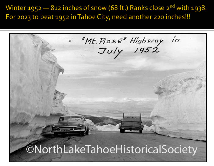
TAHOE NUGGET #252: TAHOE SURVIVES PACIFIC STORMS—BARELY!

SYNOPTIC SET UP: A “mother ship” of low pressure that originated in the Gulf of Alaska remained stationary off the Pacific Northwest coast as it shunted slugs of deep tropical moisture into northern California over the course of five days, from Nov. 28 to Dec. 2, 2012.

The official warnings were certainly ominous—an extended period of torrential rain, high elevation snow levels, and potentially major flooding on the Truckee River. Classic ingredients for what meteorologists call a “wet mantle” flood event when heavy rain washes out an existing snowpack and overwhelms the watershed, and streams and rivers breach their banks.

Yes it seemed that the components that can cause damaging floods were there (except for an established low elevation snowpack), but as it turned out the final surge of moisture turned to snow over much of the higher elevations which slowed snowmelt considerably.

Knife-like back edge to final cold front that swept through Northern California on Sunday, Dec. 2, 2012. Dry air behind the front ended heavy precipitation earlier than projected and cooler air dropped snow levels quicker than expected. The scenario eliminated threat of major flooding on Truckee River.

Residents living within the Truckee River flood plain between Squaw Creek and Donner Creek dodged a bullet this time, but that’s not to say their homes aren’t at risk. Those five days of rain and snow definitely had the potential to fulfill all the National Weather Service warnings for the Tahoe-Truckee watershed, but luckily the region was spared serious damage. In fact, we picked up a boatload of moisture and ski resorts are loving the two to four feet of fresh snow that blasted the upper elevations.

The 1997 New Years Flood damaged many homes located in the Truckee River floodplain between Squaw Valley and Truckee. They are still at risk from major winter floods.

In a reversal of the normal situation where Sierra Crest-based resorts usually receive the most snowfall, Northstar California reported the greatest storm total with 47 inches on the upper mountain.

Accumulations near lake level were measly—consider that Squaw Valley picked up 42 inches of snow at 8,200 feet, but only two inches at the base.

Virtually all the major resorts are in fairly good shape for the economically vital holiday season that’s only weeks away. If the Storm King doesn’t deliver more snow in the interim, when cold air arrives snowmaking will beef up the thin snowpack at resort bases.

When snow started falling at lake level in the Tahoe Basin on Sunday morning, flood warnings on the Truckee River were cancelled.

The recent stormy period definitely put the region on course for an above average 2013 water year. Although no records were broken, rainfall totals were impressive: Tahoe City saw 6.72 inches; Donner Lake picked up about 11 inches; Blue Canyon more than 14 inches; and La Porte, north of Truckee, was doused with nearly 18 inches. Brandy Creek, elevation 1,300 feet on the Upper Sacramento River drainage was the wettest spot in California with nearly two feet of rain.  


Lake Tahoe’s water level rose about 3.5 inches during the storm. According to the USGS, just 1/8th of an inch of water in Tahoe is equal to 397,538,220 gallons!

The NWS dubbed the persistent flow of Pacific moisture an “atmospheric river,” an apt term to describe the amount of water that poured down on the north state.  Seasonal precipitation totals in the Sierra were boosted significantly, with the Northern Sierra 8 Station Index currently averaging 220 percent of normal. (The index represents the aggregate of eight sites ranging from Highway 50 to Mt. Shasta.)

As of Dec. 5, 2012, water year 2013 is off to a roaring start, better precipitation-wise than the snowbound winter of 2011, and even ahead of the pace of 1983, the wettest winter since the index was established in 1922.

The Truckee River flood warning was issued when the NWS expected freezing levels near 9,000 feet, accompanied by heavy rain that would come rushing out of watersheds west of Highway 89, including Squaw Valley and Alpine Meadows. Forecasters predicted conditions akin to what occurred in late December 1955 during a similar hydrological event. It was called the “Storm of the Century.”

For 10 days during Christmas season 1955, a series of storms from Hawaii poured wet snow and rain on the Sierra and Northern Nevada. Officials said there was no cause for alarm, but Reno business people remembered the 1950 Thanksgiving flood that heavily damaged the city and they swung into action. Volunteers and National Guardsmen stacked walls of sandbags along the riverbank and in store entrances. Contractors supplied cranes to clear logjams and debris in the Truckee River. Parking meters were removed from downtown bridges.
 
Sure enough, two days before Christmas more than two inches of rain pounded
Reno in 24 hours. (Reno picked up only 1.34 inches of rain in the recent five day event.) Upstream nearly every power plant and bridge on the Truckee River was destroyed.

Downtown Reno underwater during the 1955 wet mantle flood event on the Truckee River.

Wet snow pulled down power lines, severing communication between Western Nevada and California. Logs jammed against bridge supports, and four feet of water flowed into Reno¹s downtown district. Many residents fled, although not before hanging their gifts high in their Christmas trees.

At Stead Air Force Base, holiday furloughs were cancelled, and hundreds of airmen with radios, jeeps, and trucks joined National Guard troops in sand-bagging and policing the streets. Finally, on Christmas Eve, cold air from the Gulf of Alaska turned the rain to snow, and the river began to recede. Overnight the swirling flakes descended on Reno¹s flood-ravaged streets, covering the debris with a mantle of snow. Reno residents awoke to their first white Christmas in years.

Ever since it was built in the Truckee River floodplain, Reno has had to deal with the volatile stream. Courtesy Reno Gazette Journal. 

This time we escaped unscathed, but whenever the Truckee threatens to spill over its banks, it helps to recall the Weather Bureau statement before the 1955 flood that “no menacing storms appear likely.”


Between storms in Carnelian Bay on Saturday, Dec. 1, 2012.

CLICK HERE TO SIGN UP FOR YOUR FREE TAHOE NUGGETS!

VISIT WWW.THESTORMKING.COM FOR MORE NUGGETS AND MUCH MORE!


Categories
Tahoe Snowstorms

#251 CALIFORNIA 2012 SUPERSTORM

TAHOE NUGGET #251: CALIFORNIA’S 2012 SUPERSTORM

California’s version of a Pacific-bred “superstorm” is currently pounding the central and northern portions of the State with damaging wind gusts and torrential rain that’s generating urban and small stream flooding. Thousands are already without power in the San Francisco Bay Area and the strongest, most potent of three storm surges is still more than 24 hours away.

This graphic depicts jet stream position with core wind speeds exceeding 140 mph. Note wind gusts up to 80 mph in western Nevada. Driving back from Reno on Thursday, Nov. 29, I observed a brush fire ripping through dry sagebrush and scrub just south of Interstate 80. 

Relatively mild temperatures are keeping snow levels generally above 7,000 feet meaning mostly rain at Lake Tahoe beaches with heavy wet snow slowly piling up on the upper slopes. Even with its higher base elevation, Kirkwood Ski Resort has picked up less than two feet on the upper mountain so far due to the slushy, condensed nature of the snow.

With the arrival of the final moisture surge late Saturday through Sunday, freezing levels are projected to rise well above 8,000 feet limiting snowfall accumulations at Lake Tahoe resorts.

Projected storm total precipitation amounts approach 15 inches near Lake Tahoe.

As the first wave of moisture moved into Northern California two days ago I decided to check out the forecast for the upper elevations of Mt. Shasta where the precipitation will be all snow. According to the National Weather Service, anticipated total snowfall accumulation at 12,366 feet is at least 18 feet, with more possible. If measureable snow falls every 24 hours (which seems likely), it can be considered a single storm event that may set a new Sierra record.

California’s current single snowstorm record is 189 inches (15.75 feet) measured over 7 days at the Mt. Shasta Ski Bowl in February 1959. Only wrinkle in this formula is that the Mt. Shasta Ski Bowl (where they’ll measure the snow) is much lower than 12,000 feet and the snow will lose a lot of its loft which means lesser totals. Despite the rain in Tahoe, with any luck we’ll set a new state snowfall record at Mt. Shasta this week!

Daily measured totals during Mt. Shasta’s 1959 record single snowstorm event.

This storm series will continue to make headlines over the next 48 hours, but one thing is clear. The timing of this rough weather couldn’t be better. A wet and warm system like this one is the principle culprit that causes virtually all the wintertime floods that strike California and western Nevada.

In 2009, scientists spent time and money to see what would happen if California picked up 8 feet of rain in 3 weeks. The media dubbed the resulting catastrophic flood event “Frankenstorm.” You have to wonder if this is an example of over-the-top newspaper hyperbole or climate change fear mongering?

Known as a wet mantle event, heavy precipitation coupled with high freezing levels pumps a huge amount of water into regional streams and rivers, sometimes even overwhelming reservoir capacity.

Deeper into the winter season the lower elevation snowpack is usually well-established and susceptible  to rapid melting, which adds water from previous cold storms to a drainage system already challenged by the typical 10 to 20 inches of rain that accompany these “atmospheric river” events on the West Coast. Several locations in the North State have reported more than 7 inches of rain in the past 24 hours alone.

Infrared satellite image from 4 kilometers above surface shows deep moisture plume surging into northern California on November 30.

These semi-tropical surges of heavy precipitation are California’s version of a hurricane with similar impacts over a large swath of territory. This time around, however, there is no low elevation snowpack to melt and regional reservoirs (including Tahoe) are all boasting hefty storage capacity. And with much of Western Nevada and Eastern California suffering serious drought conditions any spillover will help alleviate dry soil conditions there.

Even with the good news about available storage capacity, the Truckee River watershed is getting hammered and portions of the Truckee are under a flood warning, particularly between Squaw Creek and Truckee, as well as the lower stretches at Farad, Reno and Vista. The highest flows will be on Sunday (Dec. 2) due to saturated soil and continuing heavy rain.

Downstream of Squaw Valley, the Truckee River is projected to exceed flood stage by nearly 4 feet with a flow of 7,800 cubic feet per second. At Farad, near the California-Nevada border, the Truckee River is expected to hit 12,600 cfs, which is about one foot above flood stage. Moderate damage is possible to low-lying trailer and public parks, as well as some roads and bridges.

A wet mantle flood around New Year’s Day 1997 caused major damage to bridges on the upper portions of the Truckee River. Generally most damage occurs on the lower reaches of the river near Reno. Flood warnings are currently posted for this stretch of river on Sunday.

This weekend the NWS is anticipating hydrological impacts similar to Truckee River floods that occurred in 1955, 1963 and 1964. Check out my overview of historic Nevada floods.

To read about the February 1963 flood event, check out Tahoe Nugget #227:

I’m currently developing a profile about how authorities handled the Truckee River Christmas flood of December 1964 to be published in an upcoming Nugget. Stay tuned and stay dry.

CLICK HERE TO SIGN UP FOR YOUR FREE TAHOE NUGGETS!

VISIT WWW.THESTORMKING.COM FOR ALL THE NUGGETS AND MUCH MORE!